
I recently discovered the option of placing .kml and .kmz files into Google Earth. It turns out there is a raft of data files available online that can actually just be dropped into the Google Earth online version. You can then edit the layer yourself and save as a new .kml file.
FREE LAYERS: Here’s a link to layers from my first experiment – Plate Tectonics in Google Earth
How to View in Google Earth Online:
1. Download the 1. Plate Boundaries.kml and 2. Plates & Landforms.kml files.
2. Launch Google Earth
3. Click on the Projects Icon
4. Click New Project or Open Project – Import KML file from computer
5. Load either file first and repeat the process for the other (and any other layers you wish to add).
It really is as simple as that! If the file does not load up on the globe then it will be a larger .kml/.kmz file that will require the full Google Earth Pro (desktop version).
The first layer is a .kml file I discovered on the Digital Atlas Project website with data taken from the USGS. By adding extra points of reference I was able to label the plates, trenches, ridges and hotspots, which then became my second layer. To save my additions I simply created a new file by clicking the three dots and then Export as KML file. This can then be shared, viewed and edited by others.
As mentioned earlier, Google Earth online can only support smaller .kml/.kmz files, but I suppose it’s better than starting from scratch!
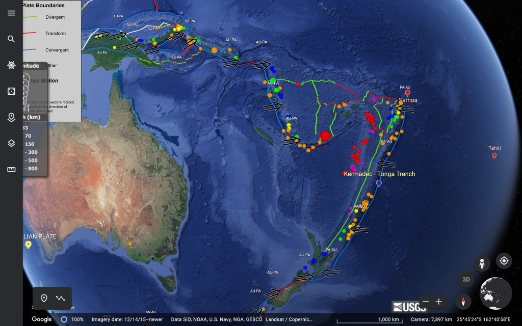
Mapping Recent Tectonic Activity
Fancy going one step further?
Huge thanks to Mark Vanstone (@wmvanstone) and Geology at Greenhead (@Geol_Greenhead) for signposting me to global seismic data of recent earthquakes that have occurred. Once the .kml file is downloaded and placed into Google Earth it will update automatically every minute!
In the file folder you will see an additional file: 2.5_month_depth.kml
Loading this into Google Earth will show you all M2.5+ earthquakes that have occurred in the past 30 days. The data and .kml file is suppled by the US Geological Survey (USGS) and more can be found here.
ArcGIS User? How about this…
Recently I took my A-Level class on a trip around our local area to search for hard & soft river/flood management strategies. Data was collected using the Survey123 app by Esri (click here for a copy of my survey template), which neatly creates a layer that can be viewed in ArcGIS online.
(Publishing a survey in Survey123 will automatically create a folder in the Content area of your ArcGIS Online account. In there you will find a .csv table of all data collected and the mapped GIS layer which will automatically update each time a survey point is completed.)


Click here for access to a copy of the completed layer in ArcGIS online.
How to View in Google Earth Online:
- Find the layer in the Content section of your ArcGIS online account.
- Click on the layer to bring up the Overview of your layer.
- In the options on the right of your screen click Export Data – Export to KML
- Give your KML file a name and save. A new KML file will appear in the same Content folder as your ArcGIS layer as a KML Collection:

Click on the three dots to download the KML file. This can then be added as a new project in Google Earth by importing the KML layer (see at the top of this post).

(Projects – New Project – Import KML file from Computer)
Why put the layer into Google Earth?
One answer… pegman! Aside from students being able to create a highly visual project that reports survey findings, picking up the pegman and dropping him into the various survey sites could develop inquiry further via Google Street View:


KML in Google Earth or ArcGIS Online?
Esri are certainly putting in the graft to make ArcGIS Online a powerful resource in the world of education. To say that it has changed the way I teach various geographies is a massive understatement; this platform is certainly the way to go when mapping, editing and working with large quantities of data (it’s free too for all schools in the UK and Ireland). However, there are those moments when we simply want to explore and the ability to place a KML layer into Google Earth and harness the wandering mentality is something not to be missed!
